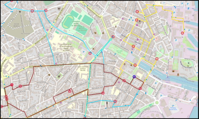
MAMUT projects (Machine learning And Matheuristics algorithms for Urban Transportation) aims to set up an open and open-source platform for solving recurring, dynamic vehicle routing problems in urban environments. These are large-scale logistics problems. The scientific and technical objectives concern the resolution of single and multi-vehicle routing problems, but also the dynamic aspect involving the real-time consideration of new demands. Three challenges are presented, including two scientific challenges (characterization of urban logistics instances, generic RO/IA hybrid solver) and one technical challenge (platform implementation). The main original feature is the hybridization of operational research (OR) with artificial intelligence (AI)
PEPR eNSEMBLE 2023eNSEMBLE is an exploratory PEPR (Priority Research Program and Equipment) funded as part of the France 2030 future investment plan. The eNSEMBLE project (Future of Digital Collaboration) aims to fundamentally redefine digital tools for collaboration. The targeted PC4-Congrats project aims to better manage very large knowledge-producing collectives such as Wikipedia. The aim is to understand how they work (for example, why people come, contribute, share, stay or leave), improve collaboration (performance, quality, well-being, results, etc.) by providing players with useful and usable tools. Through the DECIDE team's Complex Networks axis and with a multidisciplinary partnership, we will mobilize different Complex Networks-based approaches to study the mechanisms that govern the growth, structuring and sustainability of these large online collectives. In particular, we will study inter-team dynamics, involving algorithms for community detection, anomaly detection, pattern detection, and new organizational metrics for understanding large real graphs.
The PAENDORA 2 project (Planning and Developing Territorial Transition to face Climate Change) is being carried out by five public research laboratories (LISST, CNRM, Lab-STICC, LMDC, LRA) and two institutional players (FNAU, Toulouse Métropole) over a 40-month period. The project is in line with Axis 1 of the ADEME-PACT2e call for projects, which aims to reduce the impact of extreme climate hazards on urban scales. The PÆNDORA 2 project has three main objectives: 1. to further develop the urban (Geoclimate) and architectural (DANUBE) data production tools developed during the MApUCE and PÆNDORA research projects. 2. test the applicability of the data produced to operational urban planning on a development scale. In particular, we are working with Toulouse Métropole on a project to adapt the climate of schoolyards in the Toulouse area. 3. produce innovative ways of promoting and communicating project results. In particular, by creating urban microclimate walks in collaboration with the local teams involved in the case studies (LIED in Paris, CEREMA in Nancy, CRC in Dijon).
IAAP Project, ANR JCJC (2021-2025)
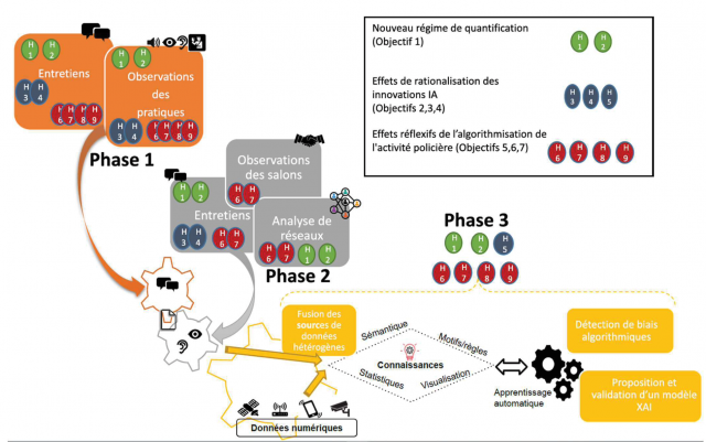
Title: The effects of Artificial Intelligence on police activity: new quantification regimes, market diversification and redefinition of urban security systems.
Keywords: Public safety policy, urban government, artificial intelligence, explainable artificial intelligence (XAI), time series, bias.
Intelligent video surveillance, facial recognition, predictive mapping, etc. are just some of the tools that are renewing police activities. They are supposed to build "safe cities" using artificial intelligence (AI). This research project is studying different cities using these technologies in order to measure and improve the practical effects of AI on police activities. In this interdisciplinary project (sociology and computer science), the objectives are to: (i) Assess the organisational changes in police activities as a result of these innovations. (ii) Characterise the relationships between the different stakeholders (scientific, industrial, public and police) in the 'safe city' and identify the technologies that are likely to meet police needs and uses, and the mutual influences that these collaborations may have on the type of AI research and police activities. (iii) Correcting and completing digital data sources (from sensors, statistics, video surveillance, etc.). By contextualising them and highlighting certain biases, the contribution is to improve the reflexivity that police can have about its own practice, by proposing a new AI approach based on explainable machine learning.
Partners: IMT Atlantique, Université de Versailles-Saint-Quentin-en-Yvelines, Sciences Po Saint-Germain-en-Laye
Past projects
Past projects we have coordinated:
Atypical project, funded by TSN Carnot (2023)
This project was carried out by Esteban Bautista, postdoctoral fellow co-supervised by Cécile Bothorel, Laurent Brisson (DECIDE team) and Grégory Smits (MOTEL team). The objective of the project is threefold: 1) identify and understand so-called regular behaviors in a potentially large interaction graph, 2) detect anomalies by taking into account structural properties (unconventional or unacceptable interactions), temporal properties (frequency of interactions) and spatio-temporal (change of affiliations to a community or sudden and massive modification of the structure of a community for example), and 3) explain the criteria which make an interaction scenario judged suspicious and thus helping decision-making actors to differentiate anomalies and emerging phenomena.
Related publication: MAD algorithm (publication in conference WSDM 2024), a statistical model modeling the interactions of a link stream through a random process.
European project Life Projet Heat&Cool (2021 - 2022)
CEREMA is a partner of Heat&Cool LIFE « Massify district heating and cooling from renewable energy sources to reduce CO2 emissions of buildings » supported by the Provence-Alpes Côte d'Azur region. As part of this project, CEREMA has requested the scientific assistance of the DECIDE team on the subject of "Mapping local climate zones (LCZ) in 15 local authorities in the PACA region". This request is part of axis A.1: Regional development potential of heating and cooling networks. The aim is to map the area's heating and cooling needs at the level of neighborhoods (IRIS grid), in order to identify areas where these networks could be judiciously extended or created, and to map the potential for network development. As the region is particularly concerned by cooling consumption, it is necessary to make an in-depth estimate (cooling, processes, etc.) on a regional scale. LThe aim of the mission is to map the 15 communities in the PACA region (Orange, Carpentras, La Garde, Hyères, Marseille, Aix, Cannes, Nice, Avignon, La Ciotat, Toulon, Fréjus, Antibes, Arles, Gardanne) from the point of view of local climate zones. Are expected: 1. LCZ map of the 15 communities; 2. description of the LCZ calculation method via software documentation and research papers; 3. the value of the average indicators (proposed by researchers Stewart and Oke) calculated for each community's LCZ. The priority indicators to be transferred to us for each LCZ in each community are average building height, average building density, ratio of vertical surface to horizontal surface, rate of grassed surface (or low stratum), rate of surface including trees (or high stratum).
The PLAMADE project, coordinated by CEREMA, aims to build a national platform to collect and collate the input data needed to produce strategic noise maps (CBS) in line with current European regulations, particularly average daily traffic data. Road managers are directly involved in validating the data, updating it and filling in the new data.
European SLIM (Surface Land Information Mapping) project (2020 - 2022)
The SLIM project, funded by ECMWF/ Copernicus Climate Change Service proposes to supply and implement two types of complementary algorithms to produce high-resolution land use and urban maps and use them in surface modeling. The main idea is to take advantage of existing algorithms and adapt them.
1. Use the second-generation Ecoclimap algorithm, developed by Météo-France, to produce a global land cover map at 300 m resolution and then aggregate the data at 1 km resolution. This algorithm will then be adapted to use the Copernicus Global Land Cover map at a resolution of 100 m instead of the current ESA-CCI LC, in order to benefit from higher resolution input data as well as more frequently updated data. 2. Use the GeoClimate tool's processing chain to provide high-resolution geographical indicators of European cities, and experiment with the production of a global map of Local Climatic Zones. These will replace those in the Ecoclimap-SG database.
Project LEARN-IA, FEDER (2019-2022)
The LEARN-IA project seeks to improve the energy performance of infrastructure in industrial and local authority environments using artificial intelligence and innovative data acquisition tools. The project involves improving the predictive analysis and recommendations provided to energy administrators using contextual information that is collected and then interpreted using semantic algorithms. The project also aims to improve the information retrieval process using technologies that enable the acquisition of non-measurable events (maintenance events, visual faults and anomalies, problems described by text, etc.) using systemic approaches:
capture these events in natural language using a suitable ergonomic input tool, by associating them if necessary with one or more physical digital measurement elements,
analysing and structuring this information using natural language processing (NLP) algorithms
extract knowledge from the links established between events and measurements using machine learning algorithms, and provide an explanation of this knowledge.
Keywords: time series, text analysis, software, XAI (explainable AI) Partners: IMT Atlantique, Energiency, Script&Go Major Publication: Ikram Chraibi Kaadoud, Lina Fahed, Tian Tian, Yannis Haralambous, Philippe Lenca. Automata-based explainable representation for a complex system of multivariate times series. IC3K 2022: 14th International Joint Conference on Knowledge Discovery, Knowledge Engineering and Knowledge Management - KDIR, Oct 2022, Valletta, Malta. pp.170-179, ⟨10.5220/0011363400003335⟩.
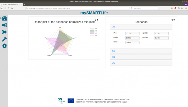
MySmartLife (H2020) (2016-2022)
The mySMARTLife project aims to make the three flagship cities of Nantes, Hamburg and Helsinki more environmentally friendly by reducing the cities' CO2 emissions and increasing the use of renewable energy sources.
As part of this project, the DECIDE team is in charge of proposing a methodology and a multi-criteria decision-support tool for planning the upgrade of the Ile de Nantes heating network, involving the network's various stakeholders and decision-makers.
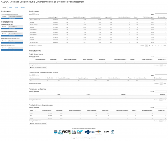
MEDISA is a research and development project aimed at creating a multi-criteria decision-making tool for sizing wastewater treatment systems. This tool is designed to take into account regulatory requirements, costs and environmental impacts.
The project is being led by a multi-disciplinary team comprising professionals from the wastewater treatment, modelling, measurement and ecotoxicology sectors, as well as academics (Eau du Ponant, IMT Atlantique (Lab-STICC), UBO (LMBA), LABOCEA, ACRI-HE, 3DEAU). The results of the project will enable those involved in wastewater treatment to make more informed decisions and contribute to environmental protection.
The DECIDE team has proposed a methodology for evaluating sanitation system improvement scenarios and implementing it in a software.
This research project on online information pluralism aims to analyze and assess the socio-economic effects of transformations brought about by digital technology on information quality and pluralism (IQP) in the media universe. PIL is a collaborative, interdisciplinary research project bringing together researchers in economics, sociology, computer science, linguistics, law and information and communication sciences.
As part of this project, the DECIDE team is working in particular on :
Analyzing interaction dynamics by developing algorithms for monitoring the evolution of communities in complex networks, so as to describe pluralism of opinion and, in particular, detect and describe the dynamics of echo chambers.
Algorithmic definition of the "quality" of a series of documents and of the "pluralism" of a given medium, using automatic natural language processing approaches.
A complete chain of automatic (or semi-automatic in some cases) analysis of document series, leading to intra-medium and/or inter-medium analyzers and rhetorics.
Academic partners: IMT Atlantique, Sorbonne Nouvelle - Paris 3 and La Rochelle Universities.
The CENSE project (Characterization of urban noise environments: towards a global approach combining open data, measurements and modeling) is a multidisciplinary project led by the UMR ACOUSTIQUE ENVIRONNEMENTALE (UMRAE), bringing together experts in environmental acoustics, data assimilation, statistics, GIS, sensor networks, signal processing and noise perception. The CENSE project aims to improve the characterization of urban noise environments, by combining in situ observations and numerical noise predictions.
Cities are particularly vulnerable to climate change due to the concentration of population, goods and infrastructure. Moreover, cities are one of the main emitters of greenhouse gases, as the high concentration of human activities, such as transport and industry, leads to high levels of energy consumption. As a result, urban actors, and urban planners in particular, are faced with numerous challenges related to climate change, while at the same time having to manage and plan their urban development in a sustainable, climate-friendly way. Climate information is mainly provided by climate models at spatial scales much larger than the (sub)urban scales at which mitigation and adaptation measures need to be implemented. The ambition of the URCLIM project is to make progress on Urban Climate Services (UCS) for urban planners and stakeholders, using open urban data and regional climate data. To achieve this goal, the project has four scientific objectives: 1. develop a methodology for creating very high-resolution urban maps to describe the parameters required for urban microclimate models, based on open-source data (such as OpenStreetMap); 2. analyze the propagation of uncertainties from regional models to sub-urban impact models; 3. carry out multi-criteria assessments of adaptation strategies, in relation to the societal aspects of heat waves, urban heat islands, intense precipitation and air quality; 4. define urban climate services in conjunction with users and urban planners. Five case studies (cities) were chosen in each of the partner countries, to reflect different geographical and climatic structures, as well as different urban histories and planning structures: Helsinki, Toulouse and Paris, Brussels and Gant, Bucharest, and the cities of the Netherlands (Rotterdam, The Hague, Amsterdam, Utrecht). http://www.urclim.eu/
ADEME PAENDORA project (2017 - 2021)
The PAENDORA project is part of a growing trend in recent years towards the development of decision-support tools for local authorities to help them take energy-climate issues into account in urban planning practices, with a marked focus on adaptation to climate change, which is less framed in terms of methodology and less integrated into local public action. The PAENDORA project is also helping to operationalize the results of other research projects, such as MApUCE. The PAENDORA project is structured around a group of trans-disciplinary partners, with the aim of developing and applying a generic approach to urban data production on the scale of urban blocks, applying it to a specific field of activity (the urban heat island), and, where appropriate, using this data to continue work on methodologies to support urban planning players in adapting to climate change.