Contact: Abdesslam BENZINOU
Context and objectives
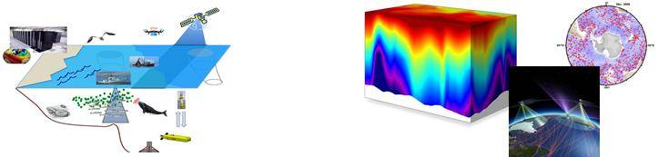
To address the environmental challenges of climate change and biodiversity loss facing society, considerable efforts have been made over several decades to increase the collection of observational environmental data (signals, images and time series). Globally, more than 90% of environmental data has been generated in the last three years. In this context, artificial intelligence (AI) techniques [1] and in particular data science and machine learning play a major role in the analysis and exploitation of environmental data/observations. The development of these technologies makes it possible to automatically perform cognitive tasks like perception, understanding and decision-making. It means, ultimately, providing support to different actors (NGOs, policy makers, civil society, and private sector) for a more effective impact on the environment and on human activities. OSE is positioned in this continuum between methodological research in signal processing & AI and the applications of interest for the environment, with a focus on multimodal remote sensing of the marine environment: i.e., oceanic remote sensing (satellite images), monitoring of the marine environment (aerial images, GNSS, ARGOS, AIS data, etc.) and underwater (passive acoustics, underwater video images).
While AI technologies seem to reach maturity, the performance of an automation task depends on the problem to be solved, the quality of the collected dataset and the learning algorithms we use. One of the concerns of the team is the performance improving of AI algorithms by deeply taking into account the nature of the phenomena to be explored (without losing the ability to generalize the tools developed to other similar use case). Three aspects of the interface between AI and monitoring of the marine environment are addressed: AI & physics, AI & robustness and AI & inverse problems. This includes, for example, the incorporation of the physics underlying the observations into learning the optimal representation for the performance of the dedicated task. The team is also involved in the robustness and adaptability of learning algorithms facing rare events, missing and/or incomplete data, and the high natural variability in environmental data. The third aspect corresponds to build AI strategies, from large datasets, for the resolution of environmental inverse problems (data interpolation, target recognition, geophysical signal inversion, information reduction, etc.). The objective is most often to estimate the hidden state of systems as well as to quantify uncertainties related to the underlying processes.
Example studies
- Physics-informed AI for ocean observation and surveillance.
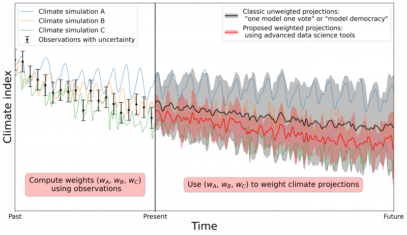
- Weighting of climate simulations, using data-driven approaches, in order to better characterize future climate projections.
- Learning variational data assimilation models and solvers.
- 3D object recognition with deep learning for automatic identification of benthic fauna.
- Assessing marine mammal diversity in the Indian ocean (Walter shoalas ans Saint Paul Amsterdam Islands) using an acoustic glider.
- Fish species recognition in unconstrained underwater videos.
Collaborations
Compagnies: Thales, NavalGroup, CLS, Eodyn, Actimar, Hytech-imaging.
Institutions: CNES, DGA, IFREMER, IUEM, INRIA, Meteo France, Mercator Ocean, IRISPACE, EUR ISblue, SHOM, FEM.
Laboratories: GIPSA, Marbec, Sorbonne Univ, UCLA (Computational and Applied Mathematics group), Univ. of Washington (Applied Phys. Lab., Applied Math. Dept), Australian Antarctic Division, Barcelona Supercomputer Center, NERSC, Univ. of Dalhousie (Institute of Big Data Analytics), IMEDEA (Espagne), RIKEN (Japon), Univ. Laval (Canada), ETH Zurich, Univ. Buenos Aires (CIMA, Argentine).
GDR : GDR ISIS.
[1] https://www.inria.fr/actualite/actualites-inria/livre-blanc-sur-l-intelligence-artificielle